Election results in Central Europe match some pre-WW1 borders
I have seen this image of Quora:
Election results are arguably one of the most apparent and easy to measure effect of complicated cultural diffences (provided that the country is sufficiently diverse to make the cultural differences relevant). After reading Albion’s seed, I think that I understand much better the origin of some of the cultural differences in the United States. The author of Albion’s seed devotes his final chapter to an analysis of the US election results until the XX century. Cultures are different through countless axes, but election results may be seen as a sort of spontaneous principal component analysis: the population spontaneously sorts itself in some political coalitions (which tend to become only two in countries with first-pass-the-post systems, and a few more in countries with proportional systems).
This looks a Prussia—Russian Empire split, rather than a city countryside split (though big cities like Warsaw vote with Prussia). Looking at the population density, the orange part does not seem much more urbanized than the blue part.
First of all, maybe this particular year is cherry-picked? Kind of: the map of other presidential elections does not correspond so neatly to the former Prussian-Russian border. But the general pattern remains.
These two regions of Poland are sometimes called Poland A and Poland B, and the developement gap between the two is widely discussed (much like the gap between northern and southern Italy). This might also be seen as a split across the Hajnal line. But the population that lives Poland A is not the same population that lived in the orange zone when it belonged to Prussia. Following the massive resettlements of the postwar period, the majority of the modern day Polish-speaking inhabitants of the Recovered Territories are not descendents of the (mostly German-speaking) inhabitants of the former Eastern Prussia.
As culture is mostly inherited, it is often hard to distinguish between inherited traits and cultural traits. To settle the issue, a possible experiment may be replacing all the inhabitants of a geographic area with a new populations, and see what happens. History has provided us with several approximations of such an experiment, and the Polish recovered territories are one. This looks to me as evidence that the economic gap between Poland A and Poland B has cultural or enviromental causes, and it is not inherited.
Poland is not the only country in Central and Eastern Europe to have underwent massive border changes in the last century. In the remaing part of this post, I will check the elections map in other countries which are across the former borders of the Austro-Hungarian Empire.
This is Romania:
With one exception, the red regions are those which belonged to the Kingdom of Romania before the Great War. Transylvania, the former Austro-Hungarian part of Romania, voted a conservative party (blue), while the former Ottoman possessions voted a socialdemocratic party (red). Ethnic hungarians have their own party (in green). According to popular stereotypes, in Transylvania people are pedantic, the buses run on time and you can not make a noise in a public library, while in Wallachia nobody cares. The border with Bulgary is a problematic area with an high criminality, after centuries of raids and constant wars between the Ottomans and their renitent romanian vassals (this is interestingly similar to the “borderer” culture of Albion’s seed). At variance with the Polish case, there have been no dramatic migrations here (through many ethnic Hungarians abandoned Transilvania after World War One, and many ethnic Romanians setteled in).
The election maps in Ukraine, instead, do not show a clear separation between the former Austro-Hungarian part and the former Russian part (unless I cherry-pick the 1991 election). This is a filo-Occidental/filo-Russian split.
What about former Czecoslovakia? We can take as an example the 1946 parliamentary elections (the last free elections before communist’s takeover):
:
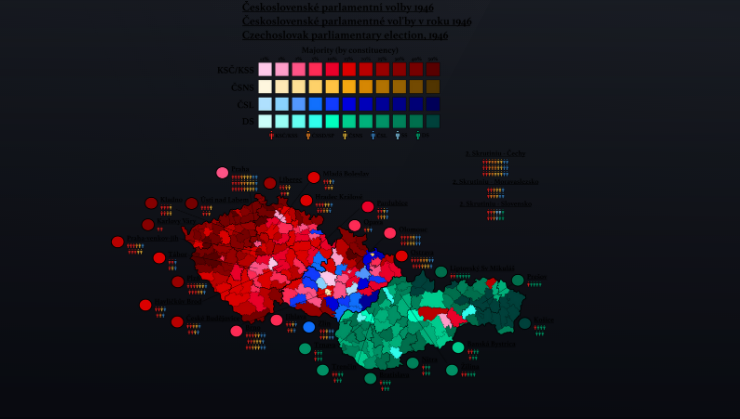
There is a clear division between Czechia on one side and Slovakia on the other side (that is, between the formely Austrian and formerly Hungarian region of Czechoslovakia). Nothing really profound or mysterious here: Czechia was the industrial core of Austria, while Slovakia’s economy was largely based on agricolture. Today Czechia and Slovakia are two separate countries, and they both have somewhat euroskeptic governments.
In Italy, my country, I see no evident correspondences between election results and former borders (although there is plenty of cultural differences—and for the formerly Austro-Hungarian regions of Italy hold the same stereotypes as for the formerly Austro-Hungarian regions of Romania).
I do not know if there is something worthy pointing out here, or if it is just a collection of trivia. However, the fact that the Polish election remain split among the former German-Russian border (despite the population replacement) looks to me as a strong argument against the inheritability of cultural differences.
Interesting reading, although I wonder if there are alternative or complementary explanations—instead of direct cultural transmission, one could think of different economic paths due to different starting levels of industrialization, infrastructure, education etc., which then generate different cultural clusters. Culture will also influence the economy, of course, in a sort of co-evolution.
Btw, if you wanted to apply this to Italy (another Italian here!), I think you should not look at coalitions but single parties within them. The Austro-Hungarian regions corresponds pretty well to the Lega Nord heartlands, for example.
But this also allows me to give an example of the alternative explanation. The historic Lega Nord vote corresponds even better with the areas where the economy is dominated by small but dynamic family-run manufacturing (north Italy, and east of Milan). You can think of Lega, pre-2010, as representing conservative voters coming from this economic and cultural background. The reasons why that part of the country ended up with this specific economic model have, as far as I know, little to do with culture and more with the timing and conditions of industrialization. Which in turn, at least in part depended on the infrastructure, institutions and levels of human capital left over from the pre-italy period.
Edit: On a second thought, you could invoke cultural history and inertia to explain the differences between eastern Lombardy and Veneto on one side, and Emilia-Romagna and Tuscany on the other. Both areas followed similar economic paths as far as I know, but they belonged to different states pre-unification and they are culturally different in a way that is very clear in the polls.
Thank you for your reply! The differences in economic developement are undoubtedly a part of the story; it is hard to isolate the “material culture” from the rest of the culture. I never said it has to be direct cultural transmission (expecially in the case of Poland, which was resettled by colonists from all the other areas of Poland. Barely one sixth of the population of Western Poland in 1950 was made of Germans who inhabited in the same place in 1939; is it enough to have direct cultural transmission? Maybe, but the quick resettlement itself may have been a cause of cultural divergence).
The economy and the environment shape the culture, but sometimes also the opposite is true (you can tell which is the border between Dominican Republic and Haiti simply by looking at Google Earth). Emilia-Romagna and Lombardy/Veneto are two sides of the same Po Valley, and as far as I know have similar densities of small manifactures: so yes, maybe the former border is a part of the explaination for the fact that they have ended up opposing each other politically.